
What a line of sight survey is, how surveyors and GIS analysts run one, and how to record results for CCTV, wireless and sensor deployments in Singapore.
Line of Sight Survey: Methods, Tools and Site Checks

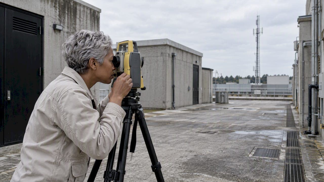
A line of sight survey establishes whether one point can see another, and if it cannot, what blocks the view. You can answer that in the field with a total station, a level or a visual check with a spotter. You can also answer it on a desk with terrain and building data in GIS software. For security and sensing projects, the survey decides where cameras, radar, beams, LiDAR and wireless links can actually work, before any cable is pulled.
This guide covers the definition, the two main methods, the field and desktop tools, what to record, and how to turn a survey into a deployment decision. It is written for integrators, facility managers and security teams in Singapore and the wider region.
TL;DR
- A line of sight is an imaginary straight line between an observer and a target. The survey tests whether anything interrupts it.
- Two routes exist: field observation with instruments, and desktop analysis using a terrain model and 3D building layers. Serious projects use both.
- Visibility is more than a straight line. Vegetation, buildings, weather and time of day all change what a sensor can really see or receive.
- Record control points, heights, obstructions and photos at each position so the result can be audited and repeated.
- For security deployments, a line of sight result should feed device placement, coverage design and a short proof of concept.
Table of Contents
- What a line of sight survey actually determines
- Where line of sight matters in security and sensing
- Field method: instruments and procedure
- Desktop method: terrain models and 3D analysis
- Field versus desktop: which to use
- Radio links: clear sight is not the whole story
- What to record so the survey stays useful
- From survey to deployment decision
- Our perspective
- How we help
- FAQ
- Sources
What a line of sight survey actually determines
Esri's GIS dictionary describes a line of sight as a conceptual line between an observer and a target, used to analyze whether the target is visible and, if not, where the view is obstructed. In surveying practice the same idea appears as the sightline through the aligned sights of an instrument such as a total station or level.
The survey therefore produces three things:
- A yes or no for each observer and target pair.
- The location and nature of any obstruction: terrain, a building, a tree line, a gantry, a container stack.
- The margin, meaning how close the line passes to an obstacle, which tells you how fragile the result is.
The third item is the one most checklists skip. A sightline that clears a parapet by ten centimeters is technically visible, but a new sign, a growing tree or a parked truck can end it.
Intervisibility and viewshed
Two terms come up in desktop work. According to the UCGIS Geographic Information Science and Technology Body of Knowledge, intervisibility analysis predicts whether one specific location is visible from another. Viewshed analysis determines the whole area visible from one or more viewpoints. Use intervisibility when you have a fixed pair, such as a rooftop radio and a gate camera. Use a viewshed when you are asking what a single mast, tower or camera position can cover.
The same reference notes that visibility analysis is applied in urban design, military observation, communications and route planning. Security design borrows from all four.

Where line of sight matters in security and sensing
Most of our readers meet this question in one of five situations:
- Perimeter detection. Photoelectric beams, radar and LiDAR need an unbroken path along the fence line or across the zone they protect.
- Camera coverage. A camera that sees the gate but not the loading bay behind a pillar leaves a blind spot that no analytics can recover.
- Wireless backhaul. Point-to-point links between buildings, rooftops or poles need a clear path and a clear zone around it.
- Guard tours and patrol routes. Checkpoints that rely on a camera view or a visual confirmation need the target to be visible from the patrol position.
- Visitor and access areas. Lobby and turnstile cameras need unobstructed views of faces and badges at realistic heights.
In each case the survey is cheap compared with relocating a mounted device after commissioning.
Field method: instruments and procedure
Field surveys give you ground truth. They capture the clutter that no model has: temporary structures, parked vehicles, reflective glass, scaffolding.
Instruments
- Total station. Gives angles and distances to features from a set-up point. Singapore's national standard for 3D topographic surveying, published in November 2013, describes observing features through radial sideshots from primary control points. It also notes that off-center corrections, available in most data collectors, handle objects that cannot be occupied directly.
- Level. Useful when the question is height difference along a path, such as whether a rooftop clears a parapet across a plaza.
- Laser rangefinder, drone or pole camera. Practical for mast and rooftop positions where you need to see the view from the mounting height rather than from the ground.
- Test equipment. For beams and wireless links, a temporary set-up beats any calculation. Our note on finding the signal peak in photoelectric beam alignment shows why a live signal reading is the final judge of alignment.
Procedure
- Establish control. Set or confirm control points before observing anything. The Singapore standard advises recording control points immediately after set-up, and re-observing them during extended observation and before moving the instrument. That check catches instrument movement before it corrupts a day's work.
- Observe from device height, not eye height. A camera at 4 m sees a different scene than a surveyor at 1.7 m. Record the planned mounting height for every position.
- Observe both ends. Check the path from observer to target and note which end is the limiting one.
- Record the obstruction and its permanence. A concrete column is permanent. A shipping container may move next month. A tree will grow.
- Photograph every position in the direction of view, with a note of time and weather.
- Close out with a clear table of pairs, result, margin and recommended action.
Keep backsights and foresights balanced
If your survey includes levelling for height differences, keep backsight and foresight distances roughly equal. Practitioner guidance such as this levelling procedure walkthrough presents equal distances as a basic safeguard against collimation error. Treat it as a field habit and confirm tolerances against the specification your project follows.
Desktop method: terrain models and 3D analysis
Desktop analysis is fast and repeatable, and it lets you test many positions before visiting the site.
Esri's documentation explains that line of sight analysis in ArcGIS uses a digital elevation model for terrain and may use 3D object or building layers to identify obstructions. Its tool reference adds that the line of sight tools calculate visibility in 3D space. They check whether the line from an observer (the first vertex) to a target (the last vertex) is blocked by surfaces or 3D objects such as multipatch features.
Two cautions apply:
- A model is only as current as its data. A building layer from before a new block went up gives a confident but wrong answer.
- Ideal conditions are an assumption. The UCGIS reference points out that vegetation can be included, while weather and time of day may be overlooked when analysis assumes ideal conditions. In Singapore, heavy rain, haze and low evening sun are routine, so camera and optical sensor results should be checked in those conditions.
Why 3D matters in dense cities: a 2007 study of urban visibility in Singapore by Perry Pei-Ju Yang and colleagues found 3D visibility indices more effective than traditional 2D ones for measuring visible urban space. For rooftops, podium levels and elevated walkways, a flat map hides the obstructions that matter.
If you are choosing GIS software for this work, it helps to test ArcGIS and QGIS on one real project before committing, especially when viewshed outputs will feed a client report.
Field versus desktop: which to use
| Question | Desktop analysis | Field survey |
|---|---|---|
| Speed for many candidate positions | Fast | Slow |
| Captures temporary clutter | No | Yes |
| Reflects current construction | Only if data is current | Yes |
| Weather and time-of-day effects | Usually assumed away | Observable |
| Evidence for approval or audit | Repeatable outputs | Photos and instrument records |
| Best use | Shortlisting positions | Confirming the final design |
The practical sequence is desktop first to narrow the options, field second to confirm them, then a trial with real devices where the stakes justify it.
Radio links: clear sight is not the whole story
For wireless backhaul, a visible path is the minimum. Radio energy occupies a zone around the straight line, called the Fresnel zone. Cisco's mesh deployment guide notes that links can still work with 60 to 70 percent of the Fresnel area unobstructed, and that 60 percent clearance of the first zone is the normally recommended figure. It also gives the formula for the zone radius from path length and frequency.
In practice, a rooftop link across a courtyard can show perfect visual sight and still lose throughput because a parapet or tree crown intrudes into that zone. Record the clearance at the midpoint, where the zone is widest, and not only at the ends.
What to record so the survey stays useful
A survey that lives only in an engineer's head cannot support a purchase order or a handover. For each observer and target pair, capture:
- Position name, coordinates and control point used
- Mounting height and orientation
- Result: clear, marginal or blocked
- Nearest obstruction, its distance and whether it is permanent, temporary or growing
- Conditions at the time of observation: weather, light, time
- Photographs in the direction of view
- Recommended action: accept, reposition, raise, add a device, or remove the obstruction
This is also the core of a good security site survey. Our site survey checklist for facility teams shows how to organize findings so they become funded fixes rather than a filed report.
From survey to deployment decision
The result should drive decisions in a clear order.
- Reposition before you add. Moving a camera two meters often removes a blind spot at no hardware cost.
- Choose the sensing method the geometry allows. Where a clean straight path is impossible, a different technology may fit better. Our write-up of a two-week proof of concept for LiDAR security detection explains how to test when detection works for an integrator before committing to a full rollout.
- Treat marginal results as risks. Put them on the register with an owner and a review date.
- Validate with devices on site. A short trial with real equipment confirms what the model predicted.
- Feed the result into operations. Coverage gaps should be known to the control room, so exception handling and patrol plans can compensate.
Our perspective
We see the same pattern on regional projects. The survey is done once, filed, and then the design changes three times. By the time devices are mounted, nobody can say which sightlines were verified and which were assumed.

Our view is that a line of sight survey is a living record, not a pre-sales formality. It should be tied to device positions, updated when the site changes, and readable by the people who will operate the system. When the visibility record sits beside the video and sensor data, a missed view stops being a surprise and becomes a known exception.
We also think automation changes what the survey needs to capture. Systems that review video continuously, such as an AI patrol agent using vision language models, can only act on what the camera can see. Knowing exactly where a view is weak tells you where to add human attention and where the analytics can be trusted to watch. Multi-vendor sites add another layer: cameras, sensors and platforms from different makers need coverage data in one place, with local validation for the standards of each market.
— Eumir
How we help
BeyondSensor works with integrators, facility owners and agencies across Singapore, Malaysia and the Philippines. If your survey points to a multi-vendor design, our Solution Integration service supports planning and deployment. For virtual guard tours and automated patrol coverage, see BeyondPatrol. Our technical tools support deployment planning.

If you want a second pair of eyes on your survey results or a candidate design, start from our home page and tell us about the site.
FAQ
What is the definition of line of sight in surveying?
It is an imaginary straight line from an observer to a target, or through the aligned sights of an instrument such as a total station or level. The survey tests whether that line is unobstructed and, if not, where it is blocked.
How do you calculate line of sight distance?
On flat open ground, distance comes straight from measurement with a total station or rangefinder. Over longer paths, height of both ends, terrain and obstructions decide whether the path is clear, so GIS tools test the line against an elevation model and 3D objects. For radio links, add the Fresnel zone clearance, with 60 percent of the first zone as the usual recommendation.
What is the difference between line of sight and viewshed?
Line of sight, or intervisibility, tests one observer and one target. A viewshed maps everything visible from a viewpoint or several viewpoints. Use the first for fixed pairs and the second for coverage planning.
Can I do a line of sight survey without going to the site?
You can shortlist positions from a terrain model and building data, but you should not finalize them that way. Models can be out of date and usually assume ideal conditions, so a site visit confirms vegetation, temporary structures and weather effects.
Who should carry out the survey for a security project?
A licensed surveyor handles control and measured topography where that is required. The security designer or integrator should define the observer and target pairs, mounting heights and the sensors involved, because those decide what the survey must prove.
Sources
- Line Of Sight Definition, GIS Dictionary (Esri)
- Intervisibility, Viewshed and Line of Sight (UCGIS GIS&T Body of Knowledge)
- Conduct line of sight analysis, 3D Workflows (ArcGIS documentation)
- How Line Of Sight works (ArcGIS Pro documentation)
- Standard and Specifications for 3D Topographic Surveying in Singapore (CORENET)
- Viewsphere: A GIS-Based 3D Visibility Analysis for Urban Design Evaluation
- Complete procedure for performing levelling (Engineersworld)
- Site Preparation and Planning, Cisco Wireless Mesh Deployment Guide
- ArcGIS vs QGIS: Test One Real Project Before You Commit
Recommended
Read More Articles

Single Sign-On Security: Risks, Controls and a Checklist
Is single sign-on secure? See how SSO works, where it fails, and the MFA, key protection and monitoring controls Singapore security teams should require.

Visitor Pre-Registration: A Practical Guide for Singapore Sites
How visitor pre-registration works at Singapore offices and industrial sites: what to collect, PDPA limits on NRIC and retention, QR check-in, and exception handling.
Fiber Optic Perimeter Security: How It Works and When to Use It
How fiber optic perimeter security detects and locates intruders, where it beats microwave sensors, and how to pilot it on a Singapore site.
Heatmap Analytics for Physical Security and Facilities
How heatmap analytics and footfall heatmaps work in buildings, how to read them, what limits their accuracy, and what Singapore's PDPA means for deployment.
Let's Build YourSecurity Ecosystem.
Whether you're a System Integrator, Solution Provider, or an End-User looking for trusted advisory, our team is ready to help you navigate the BeyondSensor landscape.
Direct Advisory
Connect with our regional experts for tailored solutioning.