
Procurement-ready guide to flood early warning sensors: choose IoT telemetry, set thresholds, build real-time dashboards, and gain 30 minute lead time.
Get 30 Minute Lead Time: Flood Early Warning Sensors for Operators

Flood early warning sensors detect rising water through in-situ instruments like ultrasonic and radar level sensors, then push that data through telemetry into a unified dashboard where thresholds and forecast models turn raw readings into actionable alerts. The strongest deployments follow this pattern: multimodal sensing, low-latency data transport, and one operations dashboard that fuses sensor readings with radar nowcasts. The World Meteorological Organization builds this exact approach into its flood forecasting guidance, and Singapore's PUB runs it at national scale. Some specialized technology companies help organizations build and integrate this stack.
TL;DR:
- Ultrasonic sensors are best for urban areas but can have blind zones; radar and pressure transducers are more suitable for rivers and high-debris sites.
- Telemetry options vary from cellular to LoRaWAN and private radio, chosen based on site remoteness, cost, latency, and reliability needs.
- Combining sensor types and implementing forecasting models can extend warning lead times from minutes to up to 30 minutes or more.
- Thresholds should be based on specific response actions and validated with historical flood data to ensure timely and effective alerts.
- Building a reliable flood monitoring system requires proper site selection, power backup, calibration, validation, and careful planning of network scaling and thresholds.
Table of Contents
- What Is a Flood Early Warning Sensor System, and How Does It Work?
- Which Sensor Technologies Detect Rising Water Best?
- How Do Telemetry and Dashboards Turn Data Into Alerts?
- How Does Forecasting Integration Extend Warning Lead Time?
- What Does a Reliable Field Deployment Actually Require?
- How Should You Set Flood Alert Thresholds and Lead Times?
- What Belongs in a Flood Sensor Procurement Checklist?
- How BeyondSensor Supports Flood Monitoring Deployments
- What Should Agencies Fund First?
- Ready to Build Your Flood Monitoring System?
- Sources
- FAQ
What Is a Flood Early Warning Sensor System, and How Does It Work?
A sensor-based flood early warning system works in three layers: sensing, transport, and decision support. Each layer has a job, and skipping one weakens the whole chain.
In-situ water level sensors, rain gauges, and CCTV feeds form the sensing layer, capturing conditions at drains, rivers, and coastal points. Weather radar adds a wide-area view that ground sensors cannot provide alone. Telemetry then carries that data, often at one-minute intervals in dense IoT deployments, to a central platform. From there, the dashboard layer applies thresholds and forecast logic to decide who gets notified and how urgently.
The system typically splits into two alert paths:
- Operator alerts: detailed, high-frequency data feeding control room dashboards for tactical decisions like deploying barriers or closing roads.
- Public alerts: simplified SMS or app notifications triggered only at defined severity levels, avoiding alert fatigue.
Singapore's PUB runs both paths through its Catchment and Waterways Operations System, which fuses sensor data with radar to move teams from reactive patrolling toward intelligence-driven response.
Which Sensor Technologies Detect Rising Water Best?
No single sensor type covers every flood scenario. The right choice depends on flow conditions, debris load, and how much maintenance a site can absorb.
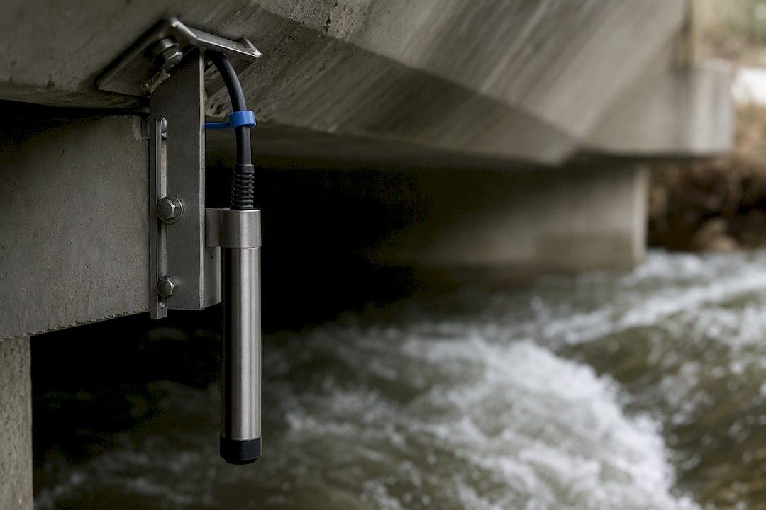
Ultrasonic sensors dominate urban drain and canal monitoring because they're inexpensive and easy to install above the water surface. A recent review of flood sensor technologies confirms this is the default choice for city networks, though ultrasonic units struggle with foam, heavy rain interference, and a blind zone near the sensor face.
Pro Tip: Ultrasonic sensors can reach roughly 0.1 cm accuracy under controlled lab conditions, but field deployments typically carry a blind zone of about 3 cm near the sensor head, so budget that margin into your alert thresholds rather than assuming lab-grade precision.
- Pressure transducers submerge directly in water and measure depth through hydrostatic pressure, but they need regular barometric compensation to stay accurate as atmospheric pressure shifts.
- Non-contact radar handles high-flow, high-debris rivers better than ultrasonic or submerged options because it never touches turbulent or contaminated water.
- Rain gauges and weather radar don't measure water level directly, but they provide the leading indicator that lets a system anticipate a rise before it reaches the channel.
The peer-reviewed literature increasingly recommends fusing two or more of these types rather than relying on one sensor per site.
How Do Telemetry and Dashboards Turn Data Into Alerts?
Raw sensor readings are useless until they reach someone who can act. That's the job of telemetry and the operations dashboard sitting on top of it.
Cellular connectivity works well for sites with existing coverage and moderate power budgets, while LoRaWAN suits remote, low-bandwidth deployments needing years of battery life. Private radio networks remain the choice for agencies that can't tolerate carrier outages during a storm. Each trade-off comes down to latency versus coverage versus cost, and most large networks end up mixing all three depending on site remoteness.

Edge processing on the sensor node itself, rather than waiting for a round trip to the cloud, cuts the delay between a threshold breach and an alert firing. That matters most for flash-flood-prone urban drains where minutes decide outcomes.
A dashboard built for flood operations needs:
- Real-time map visualizations showing sensor status and current readings at a glance.
- Role-based views so field crews see different data than executive stakeholders.
- Configurable alerting rules tied to specific thresholds per site.
- Open APIs for pushing alerts into SMS gateways, sirens, or third-party emergency systems.
BeyondSensor's approach to risk-based sensing applies this same dashboard logic across monitoring domains, consolidating disparate feeds into one operational view.
How Does Forecasting Integration Extend Warning Lead Time?
Sensors alone tell you what's happening now. Forecasting integration tells you what's coming in the next 30 to 60 minutes, and that window is what actually saves lives and property.
Short-range radar nowcasts extend lead time meaningfully. PUB's CWOS uses X-band weather radar to generate a 30-minute rainfall prediction window, layered on top of live water level readings from over 1,000 sensors and 500-plus CCTV cameras.
- Level-to-level correlations let upstream sensor readings calibrate downstream forecast models, improving accuracy over time as more events accumulate in the dataset.
- Threshold-only alerts suit short-response basins with little forecasting infrastructure. It's the pragmatic starting point WMO recommends for agencies still building capacity.
- Model-driven alerts add real value once an agency has enough historical data and computing capacity to run hydrodynamic models reliably.
Starting simple and adding complexity as data accumulates matches how WMO frames iterative EWS implementation generally.
What Does a Reliable Field Deployment Actually Require?
Getting a sensor into the ground is the easy part. Keeping it accurate, powered, and reporting for years is where most flood monitoring programs actually succeed or fail.
- Site selection first. Place sensors where upstream and downstream relationships are well understood, and prioritize critical infrastructure like pump stations, bridges, and low-lying residential zones.
- Power redundancy. Solar with battery backup is standard for remote sites; tamper-resistant enclosures and anti-vandalism mounts protect against both weather and interference.
- Calibration cycles. Schedule periodic barometric and temperature corrections, since both introduce measurable bias into pressure transducers and ultrasonic readings over time.
- Post-event validation. Compare sensor logs against actual flood extent after every significant event to catch drift before it corrupts the next forecast cycle.
- Network scaling. Plan gateway placement and spectrum allocation before adding nodes, not after.
Pro Tip: Dense sensor networks often run into RF interference and packet collisions as node counts climb. Plan gateway placement and fallback communications, cellular or satellite, for your most critical nodes well before you scale past a pilot deployment.
How Should You Set Flood Alert Thresholds and Lead Times?
Thresholds only work when they're tied to a specific action someone will actually take. A threshold with no corresponding response protocol is just a number on a dashboard.
WMO guidance ties lead-time ranges to user needs directly, meaning the forecast product you build depends entirely on how much time your response teams need to act.
PUB's public alert system illustrates progressive thresholds in practice, notifying subscribers at defined progressive stages of canal depth, escalating urgency as water rises.
- Map each threshold tier to a specific operator action, not just a notification.
- Validate thresholds against historic flood events before going live, using time-of-travel analysis for the basin.
- Revisit thresholds annually since urban development changes runoff patterns.
What Belongs in a Flood Sensor Procurement Checklist?
Comparing vendor bids gets easier once you write specs down before requesting proposals, not after reviewing what everyone offers.
- Sensor specifications: stated accuracy under field conditions (not just lab conditions), IP-rated environmental tolerance, and expected maintenance interval.
- Telemetry service levels: maximum latency, acceptable packet loss, fallback communications for outages, and encryption standards for data in transit.
- Platform service levels: dashboard uptime commitments, alert delivery channels (SMS, API, siren integration), data retention periods, and role-based access controls.
BeyondSensor's guide to infrastructure sensor selection breaks down comparable specification categories for teams building their first RFP.
How BeyondSensor Supports Flood Monitoring Deployments
Some technology companies have presence in Southeast Asia, offering regional teams localized deployment support rather than a one-size-fits-all rollout. Solution Integration services help agencies move from pilot to full deployment, while Ecosystem Matchmaking connects procurement teams with the right sensor and telemetry vendors for their specific basin conditions...
What Should Agencies Fund First?
Before densifying a sensor network, get the basics right: reliable key-point sensors with solid telemetry, an operator-ready dashboard, and clear standard operating procedures. Schedule realistic testing cycles. A sprawling network feeding a dashboard nobody trained on solves nothing.
— Eumir
Ready to Build Your Flood Monitoring System?
Most agencies evaluating flood sensors end up piecing together hardware from one vendor, telemetry from another, and a dashboard built in-house, then discover the integration gaps only after a storm exposes them. BeyondSensor closes that gap directly: Solution Integration handles the sensor-to-dashboard pipeline as one coordinated deployment instead of three separate procurement headaches.
For procurement teams still comparing vendors, Ecosystem Matchmaking connects you with the right sensor and telemetry partners for your basin's specific conditions before you commit to a bid. If your organization is planning a pilot, start with a discovery call and site survey. Get in touch with BeyondSensor to scope your deployment and see how a unified sensor-to-alert stack fits your existing operations.
Sources
- Flood Forecasting and Monitoring | PUB, Singapore's National Water Agency
- Manual on flood forecasting and warning (WMO No. 1072)
- A review of cutting-edge sensor technologies for improved flood monitoring and damage assessment
- IoT-based Flood Early Warning System for Effective ... (IEEE)
FAQ
What Type of Sensor Is Used for Flood Detection?
Ultrasonic sensors are the most common choice for urban drain and canal monitoring due to their low cost and ease of installation above the waterline. Non-contact radar and pressure transducers are used at rivers and coastal sites where debris or submersion make ultrasonic sensors less reliable, according to a peer-reviewed sensor technology review.
What Are the Early Warning Systems for Floods?
Early warning systems combine water level sensors, rain gauges, and weather radar with telemetry and a central dashboard that applies alert thresholds. Singapore's PUB runs one of the most developed examples through its Catchment and Waterways Operations System, integrating over 1,000 water level sensors with radar nowcasts.
How Does a Flood Sensor Work?
A flood sensor measures water depth or level using ultrasonic sound waves, radar reflection, or pressure readings from a submerged transducer. That reading transmits via telemetry to a platform that compares it against preset thresholds and triggers an alert once a limit is crossed.
What Is a Flood Early Warning Device and How Does It Work?
A flood early warning device is a sensor paired with a telemetry module that reports water level readings to a central monitoring platform at regular intervals, often every one to five minutes. The platform evaluates those readings against defined thresholds and forecast models, then issues alerts to operators or the public before flooding becomes severe. BeyondSensor helps organizations integrate these devices into a single operational dashboard through its Solution Integration service.
How Much Lead Time Do Flood Sensors Typically Provide?
Lead time depends on the basin's response speed and whether the system uses threshold-only alerts or forecast models. Systems incorporating short-range radar nowcasts, like PUB's roughly 30-minute prediction window, extend warning time well beyond what raw sensor readings alone can provide.
Recommended
Read More Articles
RTSP Security Risks: Integrators Must Block Exposed Ports 554 and 8554
See how integrators can reduce RTSP security risks: close exposed ports 554 and 8554, secure camera access, and verify each deployment with practical checks.
Require MAEpp and X Accuracy Before You Buy People Counting Systems
Verify people counting accuracy by demanding MAEpp, X Accuracy, and directional-bias reports. Validate on-site with at least 100 events per direction...
30–90 Day Pilot Validates Redundant Camera Networks for Engineers
Standards led, practical steps for engineers to deploy redundant camera networks: MRP, dual homing, and aggregation patterns, commissioning checks, and...
30 Day Pilot Proves Video Analytics Accuracy for Security Teams
Validate video analytics accuracy with scenario tests, camera tuning, transfer learning and a 30 day edge first pilot for security teams.
Let's Build YourSecurity Ecosystem.
Whether you're a System Integrator, Solution Provider, or an End-User looking for trusted advisory, our team is ready to help you navigate the BeyondSensor landscape.
Direct Advisory
Connect with our regional experts for tailored solutioning.